Moscow Metro

Information for tourists about the Moscow Metro.

  • Pushkinskaya, Tverskaya, and Chekhovskaya metro stations in Moscow

    The Pushkinskaya, Tverskaya, and Chekhovskaya metro stations in Moscow are located northwest of the city center, approximately 1.5 kilometers from the Kremlin and Red Square. The stations have exits at the intersection of Tverskaya, Tverskoy Bulvar, and Strastnoy Bulvar Streets, as well as at Pushkinskaya Square. These stations form a major transfer hub for three Moscow Metro lines.

    Pushkinskaya Metro Station

    Pushkinskaya metro station is located on the Tagansko-Krasnopresnenskaya Line (Purple Line, Line 7) of the Moscow Metro, between Barrikadnaya and Kuznetsky Most stations. Here you can transfer to the Zamoskvoretskaya Line (Tverskaya station) and the Serpukhovsko-Timiryazevskaya Line (Chekhovskaya station).
    The station opened on December 17, 1975. The station is 51 meters deep. The central station hall is 8.2 meters wide and 6.25 meters high.

    Pushkinskaya Metro Station has two underground vestibules.
    The western underground vestibule is shared by Pushkinskaya and Tverskaya stations. It has two underground halls connected by two passages (the ticket office is also located here). The vestibule has an exit onto Tverskaya Street and an underground passage.
    The eastern underground vestibule is shared by Pushkinskaya and Chekhovskaya stations. It has an exit to an underground passage under Strastnoy Boulevard.

    Tverskaya Metro Station

    Tverskaya Metro Station is located on the Zamoskvoretskaya Line of the Moscow Metro (Line 2, marked in green on the map), between Mayakovskaya and Teatralnaya stations. The station opened on July 20, 1979. Until November 5, 1990, the station was known as Gorkovskaya. The station has transfers to Pushkinskaya Station on the Tagansko-Krasnopresnenskaya Line and Chekhovskaya Station on the Serpukhovsko-Timiryazevskaya Line.

    The station is entered through a shared underground vestibule (antechamber) with Pushkinskaya Station, located under Pushkinskaya Square. Exit from the vestibule to the city is through underground passages to the Izvestia Publishing House building, Tverskaya Street, and the Tverskoy Passage shopping center.
    The transfer to Pushkinskaya Station is located in the center of the hall.
    The transfer to Chekhovskaya Station is located at the southern end of the station’s boarding hall.

    Chekhovskaya Metro Station

    Chekhovskaya Metro Station is located on the Serpukhovsko-Timiryazevskaya Line of the Moscow Metro (Line 9, shown in gray on maps), between Tsvetnoy Bulvar and Borovitskaya stations. The station opened on December 31, 1987. The station is 62 meters deep.

    Chekhovskaya Metro Station is located at the intersection of Strastnoy Bulvar, Malaya Dmitrovka, and Bolshaya Dmitrovka Streets, near Pushkinskaya Square.

    The transfer to Pushkinskaya Station on the Tagansko-Krasnopresnenskaya Line is located in the center of the station hall. The transfer to Tverskaya Station on the Zamoskvoretskaya Line is located at the western end of the station’s central hall.
    Exit to the city is via an underground passage and a ground-level vestibule located in the building on Pushkinskaya Square.

    👉 Look at the station location on the map.

    Near the Pushkinskaya, Tverskaya, and Chekhovskaya metro stations in Moscow, you’ll find, for example:

    • Lenkom Theater.
    • Stanislavsky and Nimirovich-Danchenko Musical Theater.
    • Young Spectator’s Theater (TYUZ).
    • Museum of the History of Modern Russia.
    • Several hotels.
    • Hermitage Garden.
  • Teatralnaya Metro Station in Moscow.

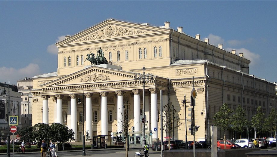
    Teatralnaya metro station in Moscow is located in the city center, beneath Teatralnaya Square. The station is on the Zamoskvoretskaya Line of the Moscow Metro (green line), between Tverskaya and Novokuznetskaya stations. Teatralnaya is connected by passages to Okhotny Ryad and Ploshchad Revolyutsii stations. The Bolshoi and Maly Theaters of Moscow are located near Teatralnaya.

    The station opened on September 11, 1938. It is located at a depth of 35 meters. Structurally, the station consists of three parallel tunnels connected by passages. The cross-section of each tunnel is 9.5 meters. The total platform width is 22.5 meters; the distance between tracks is 25.4 meters. The arch height is 5.3 meters. The total platform length is 155 meters.

    Bolshoi Theater

    Teatralnaya station is the center of a major transfer hub. From here, you can transfer to Okhotny Ryad station on the Sokolnicheskaya Line and Ploshchad Revolyutsii station on the Arbatsko-Pokrovskaya Line. There are two ways to get to each of these stations: via underground passages and through shared above-ground vestibules.
    The passages are located in the center of Teatralnaya Station, accessible via stairs above the tracks.

    Teatralnaya metro station has two above-ground vestibules.
    Teatralnaya’s southern vestibule is shared with Ploshchad Revolyutsii station and is located on Revolyutsii Square.

    Teatralnaya’s northern vestibule is shared with Okhotny Ryad station and is the closest exit to the theater. This vestibule is built into a building at the intersection of Bolshaya Dmitrovka Street and Teatralny Proyezd Street, on the edge of Teatralnaya Square. A passage leads from this vestibule to the Teatralnaya escalator.

    👉 Look at the station location on the map.

    Near the Teatralnaya metro station in Moscow are:

    • The Bolshoi Theater. Address: Teatralnaya Square, 1.
    • The State Academic Maly Theater of Russia. Address: Teatralny Proyezd, 1.
    • The Russian Academic Youth Theater. Address: Teatralnaya Square, 2.
    • The Moscow Operetta. Bolshaya Dmitrovka Street, 6.
    • The Chekhov Moscow Art Theater. Kamergersky Lane, 3.
    • The Moscow State Exhibition Hall. Georgievsky Lane, 3.
    • Red Square.
    • The Moscow Kremlin.
    • The State Historical Museum.
    • Four Seasons Hotel Moscow. Okhotny Ryad Street, 2.
    • The Metropol Hotel. Teatralny Proyezd, 2.
    • TsUM — Central Universal Department Store. Petrovka Street, 2.
  • Kurskaya and Chkalovskaya Metro Stations in Moscow

    The Kurskaya and Chkalovskaya metro stations in Moscow are located approximately 2.5 kilometers east of the city center (The Kremlin and Red Square), next to Kursky Railway Station.
    Kurskaya metro stations are located on two Moscow Metro lines: the Arbatsko-Pokrovskaya Line (Line 3, blue line) and the Circle Line (Line 5, brown line).
    Chkalovskaya metro station is located on the Lyublinsko-Dmitrovskaya Line (Line 10, light green line) of the Moscow Metro. The stations are connected by passages, allowing transfers between the three metro lines.

    Kurskaya Metro Station (Arbatsko-Pokrovskaya Line)

    Kurskaya metro station on the Arbatsko-Pokrovskaya Line of the Moscow Metro is located between Baumanskaya and Ploshchad Revolyutsii stations. The station opened on March 13, 1938. The station’s boarding hall is located under Zemlyanoy Val Street. The station exit (escalators) is located at the eastern end of the hall.

    The station has transfers to the station of the same name on the Circle Line and to the Chkalovskaya station on the Lyublinsko-Dmitrovskaya Line. The transfer to the Circle Line is in the center of the hall. The transfer to the Lyublinskaya Line is at the western end of the hall.

    The station exits through a round underground hall, next to which are the ticket counters. This same hall also provides access to the Circle Line station. From the station, you can exit into the Kursky Station waiting room, the above-ground concourse (located on the first floor of a residential building on Kursky Station Square), and through a pedestrian crossing under the railway tracks to Nizhny Susalny Lane.

    Kurskaya Metro Station (Circle Line)

    Kurskaya Station on the Moscow Metro’s Circle Line is located beneath Kursky Station Square between Komsomolskaya and Taganskaya stations.
    The station opened on January 1, 1950.

    The station has two vestibules. The northern vestibule is shared with the Arbatsko-Pokrovskaya Line station. It is located in the northern part of Kursky Station Square and has exits into the station building and onto the square. The southern vestibule is located in the southern part of Kursky Station Square and is shared with Chkalovskaya Station.

    The transfer to Kurskaya Station on the Arbatsko-Pokrovskaya Line is located in the center of the station’s boarding hall (stairs above the platform, then along a corridor). Transfer to Chkalovskaya Station is through a vestibule shared by both stations.

    Chkalovskaya Metro Station

    Chkalovskaya Metro Station is located on the Lyublinsko-Dmitrovskaya Line of the Moscow Metro, between Sretensky Bulvar and Rimskaya stations. The station opened on December 28, 1995. From the station, you can transfer to Kurskaya Station on the Arbatsko-Pokrovskaya and Koltsevaya Lines.

    The transfer to Kurskaya Station on the Arbatsko-Pokrovskaya Line is located at the northern end of the central hall. The transfer to Kurskaya Station on the Koltsevaya Line is at the southern end of the hall. Exit to the city and transfer to the Koltsevaya Line are via the above-ground vestibule. The vestibule is shared by both stations and is located in the southern part of Kursky Station Square.

    The station’s design is dedicated to the famous pilot Valery Chkalov (1904-1938). When the station was designed, Zemlyanoy Val Street was named Chkalov Street. This explains the choice of the station’s name. In 1992, the street was reverted to its historical name.

    👉 Look at the station location on the map.

    Near the Kurskaya metro station and Kursky Railway Station in Moscow are:

    Kursky Railway Station.
    Atrium Shopping Center.

    Learn more about Moscow.

  • Arbatskaya Metro Stations in Moscow

    Arbatskaya metro stations are located on two lines of the Moscow Metro: the Arbatsko-Pokrovskaya Line and the Filevskaya Line. The stations are located in the center of Moscow, approximately 1 kilometer from Red Square and the Moscow Kremlin. The station ground-level concourses are located near Arbatskaya Square and famous Moscow streets: Arbat, Novy Arbat, and Vozdvizhenka.

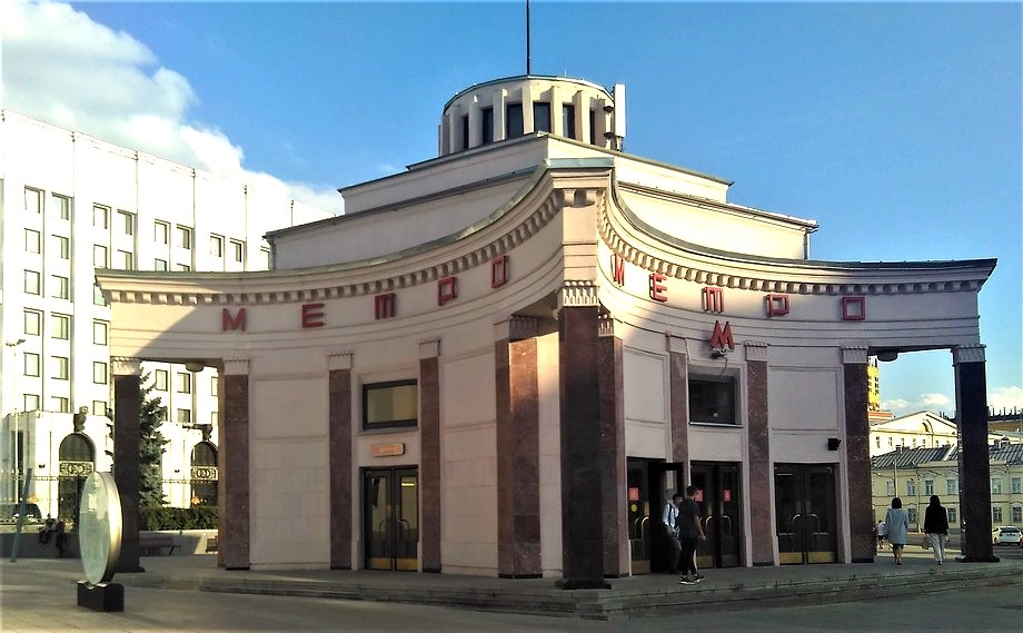
    The lobby of the Arbatskaya metro station. Arbat Street.

    Arbatskaya Metro Station (Arbatsko-Pokrovskaya Line)

    Arbatskaya metro station on the Arbatsko-Pokrovskaya Line of the Moscow Metro is located between Ploshchad Revolyutsii and Smolenskaya stations. The station opened on April 5, 1953. The station’s underground hall is 220 meters long (one of the longest halls in the Moscow Metro). The station’s depth is 41 meters.

    Arbatskaya metro station on the Arbatsko-Pokrovskaya Line of the Moscow Metro is part of Moscow’s largest transfer hub (connecting four stations on four metro lines). From this station, you can transfer to Biblioteka Imeni Lenina on the Sokolnicheskaya Line, Aleksandrovsky Sad on the Filevskaya Line, and Borovitskaya on the Serpukhovsko-Timiryazevskaya Line.

    The station’s ground-level vestibule is located near the intersection of Vozdvizhenka Street and Krestovozdvizhensky Lane. The vestibule is integrated into the building of the Russian Ministry of Defense.
    Transfers to the Sokolnicheskaya (Biblioteka imeni Lenina station) and Filevskaya (Aleksandrovsky Sad station) lines are via an escalator located at the eastern end of the vestibule (from there, you can also exit to the city at Aleksandrovsky Sad and Mokhovaya Street). A staircase located in the center of the vestibule leads to Borovitskaya station (Serpukhovsko-Timiryazevskaya line). There is no transfer to Arbatskaya station on the Filevskaya line (2014).

    Arbatskaya Metro Station (Filyovskaya Line)

    Arbatskaya station on the Moscow Metro’s Filevskaya line is located between Aleksandrovsky Sad and Smolenskaya stations. Built on the site of a 17th-century church, the station opened on May 15, 1935. The station is 8 meters deep. The station’s ground-level vestibule is located on Arbatskaya Square, near Znamenka, Gogolevsky Boulevard, Arbat, and Novy Arbat streets. The ground-level vestibule is a separate building shaped like a five-pointed star. The station’s vestibule became one of the first symbols of the Moscow Metro.

    👉 Look at the station location on the map.

    Near the Arbatskaya metro station in Moscow are:
    Pedestrian Arbat Street (one of Moscow’s landmarks).
    The Vakhtangov Theater.
    The distance to the Kremlin is approximately 750 meters.

  • Ploshchad Revolyutsii Metro Station in Moscow

    Ploshchad Revolyutsii Metro Station is located in the very center of Moscow, close to many famous landmarks and popular tourist spots. The station is also known for the sculptures located in its underground concourse.

    Ploshchad Revolyutsii Metro Station is a station on the Arbatsko-Pokrovskaya Line of the Moscow Metro. It is located between Kurskaya and Arbatskaya stations. The station has a connecting connection to Teatralnaya Station on the Zamoskvoretskaya Line, from where you can transfer to Okhotny Ryad Station on the Sokolnicheskaya Line of the Moscow Metro.

    The station opened on March 13, 1938. The entrances from this station are located next to Ploshchad Revolyutsii (hence the name). The station was designed by architect A.N. Dushkin.

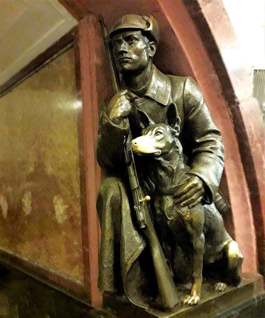
    Sculpture at the Ploshchad Revolyutsii metro station in Moscow

    A few figures: depth – 34 meters; The overall platform width is 22.5 meters; the distance between tracks is 25.4 meters; the height of the boarding hall vault is 5.3 meters; and the platform length is 155 meters.

    The station has two above-ground vestibules. The western vestibule is located on Revolution Square and is shared with Teatralnaya Station (from here, you can go to both Revolution Square and Teatralnaya Stations). The station’s eastern vestibule is built into a building located on the corner of Bogoyavlensky Lane and Nikolskaya Street.

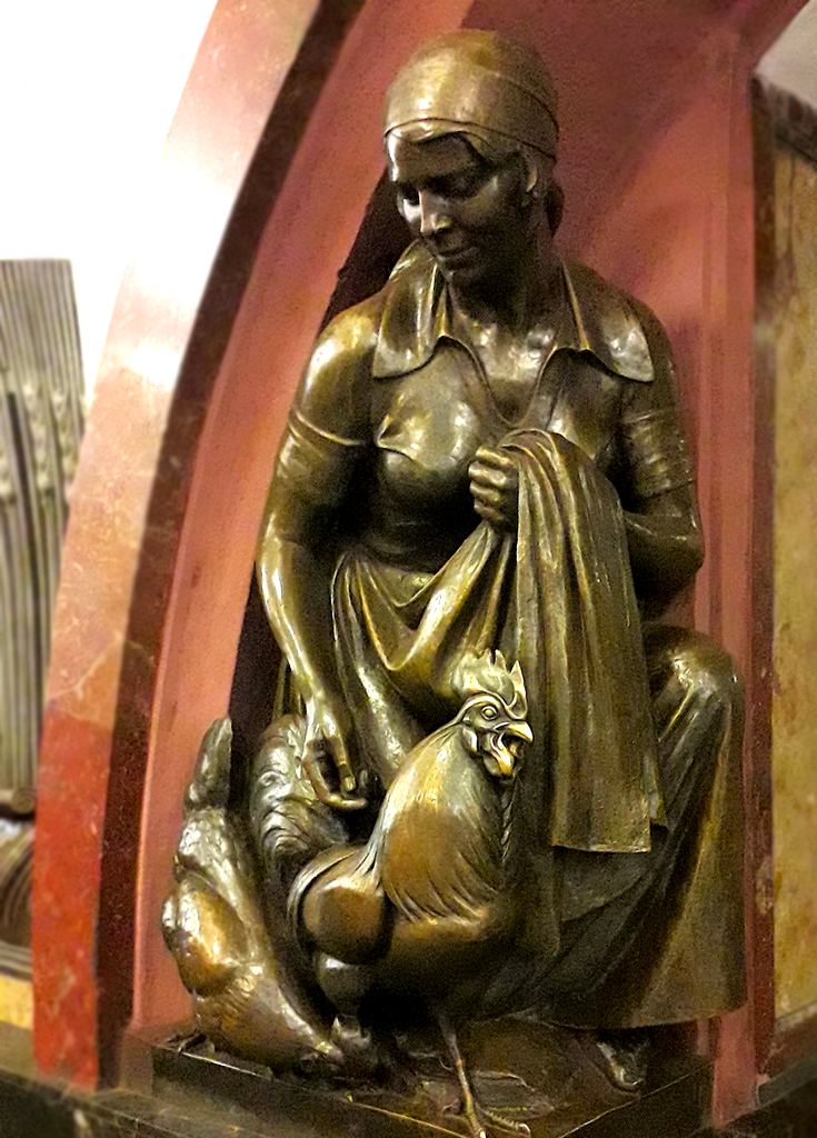
    A distinctive feature of Revolution Square metro station are the bronze sculptures located in its underground vestibule. There are 76 sculptures in total, 18 of which are repeated four times, and two of which are repeated twice. The sculptures depict a total of 20 images. The sculptures were created at the Leningrad Art Casting Workshop under the direction of sculptor M. G. Manizer. The sculptures installed at the station depict Soviet people, as was common practice in the USSR during the station’s construction. They depict workers, peasants, soldiers, sailors, students, etc. The sculptures were intended to serve as a kind of propaganda tool. Today, they can be considered a cultural monument of the USSR of the mid-20th century.

    Sculpture at the Ploshchad Revolyutsii metro station in Moscow

    Some of the sculptures are associated with certain superstitions. For example, to ensure you pass an exam, you should rub the nose of the dog near the “Border Guard with a Dog” sculpture; touching the revolver near the revolutionary sailor sculpture will ensure a successful day.

    👉 Look at the station location on the map.

    Some of the landmarks located near the Ploshchad Revolyutsii metro station:

    Moscow Kremlin. The Moscow Kremlin is the main landmark of the Russian capital and a symbol of Russia. The Kremlin grounds are the historical center of the city. The Moscow Kremlin Museum manages the Kremlin’s tourist attractions.
    Red Square. Red Square is the main square of Russia. All tourists visiting the Russian capital stop by this place. The square is home to the Kremlin’s most famous tower, the Spasskaya Tower. (Distance from the metro station is approximately 240 meters.)
    St. Basil’s Cathedral. The most famous cathedral in Moscow and Russia (Pokrovsky Cathedral). One of Moscow’s most beautiful churches. (Distance approximately 500 meters.)
    Kazan Cathedral. (Cathedral of Our Lady of Kazan.)
    Bolshoi Theater. Russia’s most famous theater. The theater is known throughout the world. (Distance approximately 370 meters.)
    Historical Museum. Russia’s largest historical museum is located on Red Square. (Distance approximately 250 meters.)
    Polytechnic Museum (Distance approximately 650 meters.)

  • Okhotny Ryad Metro Station

    Okhotny Ryad metro station is located in the historic center of Moscow, close to the city’s main landmarks. It is the closest station to Red Square. Okhotny Ryad is a station on the Sokolnicheskaya Line of the Moscow Metro. The station is located between Lubyanka and Biblioteka imeni Lenina stations, at the intersection of Mokhovaya and Tverskaya Streets, next to Manezhnaya Square.

    Okhotny Ryad metro station opened on May 15, 1935. The origin of the station’s name is connected to the city’s history. In the 18th and 19th centuries, a square where hunters’ catches were sold stood here, next to the walls of the Moscow Kremlin. The square was called “Okhotny Ryad Square,” later renamed to Okhotny Ryad Street.

    The station’s name was influenced by the political events taking place in the country. This is the only station in Moscow to have changed its name four times: Okhotny Ryad (1935-1955), Imeni Kaganovicha (1955-1957), Okhotny Ryad (1957-1961), and Prospekt Marksa (1961-1990). Since 1990, the station has been renamed its historical name, Okhotny Ryad, for the third time.

    From Okhotny Ryad Station (Sokolnicheskaya Line), you can transfer to Teatralnaya Station on the Zamoskvoretskaya Line. The transfer is via escalators located in the center of the station hall, as well as through a combined vestibule. The station has exits to Teatralnaya Square and Manezhnaya Square (also the shopping center under Manezhnaya Square). You can also transfer to Ploshchad Revolyutsii Station on the Arbatsko-Pokrovskaya Line (via Teatralnaya Station).

    👉 Look at the station location on the map.

    Near the Okhotny Ryad metro station in Moscow are:

    • Moscow Kremlin. The Moscow Kremlin is the main landmark of the Russian capital and a symbol of Russia.
    • Red Square. Red Square is Russia’s main square. All tourists visiting the Russian capital visit this place.
    • St. Basil’s Cathedral. The most famous cathedral in Moscow and Russia. One of the most beautiful churches in Moscow. (Distance from the metro station is approximately 650 meters.)
    • Kazan Cathedral.
    • Vasilyevsky Spusk. Vasilyevsky Spusk Square is located between St. Basil’s Cathedral and the Moskva River. Various public events are often held here.
    • Russian National Library. (Distance approximately 600 meters.)
    • Bolshoi Theater. Russia’s most famous theater. The theater is known throughout the world. (Distance approximately 400 meters.)
    • History Museum. Russia’s largest history museum is located on Red Square. (Distance approximately 250 m.)
    • Okhotny Ryad Shopping Center (located under Manezhnaya Square).
  • VDNKh Metro Station


    VDNKh Metro Station in Moscow is located at a distance of approximately 8 kilometers north of the city center (Kremlin and Red Square), close to the exhibition center VDNKh. Station hall is located near the intersection of Prospekt Mira street, Kosmonavtov street and Academika Koroleva street.

    Metro station VDNKh (станция метро ВДНХ, Exhibition Center) is located at Kaluzhsko-Rizhskaya line of the Moscow Metro (line 6, orange line) between stations “Botanical Garden” and “Alekseevskaya”. Passengers can make a change to the station “Vistavochny Tsentr” of Moscow monorail transport system from the station.

    Metro station VDNKh (станция метро ВДНХ, Exhibition Center) is located at Kaluzhsko-Rizhskaya line of the Moscow Metro (line 6, orange line) between stations “Botanical Garden” and “Alekseevskaya”. Passengers can make a change to the station “Vistavochny Tsentr” of Moscow monorail transport system from the station.

    Station was open May 1, 1958. The station has two lobbies. Ground lobby is located next to the Prospekt Mira street. The second vestibule (underground) is just south. It has access to the underpass under the Prospekt Mira.

    There are located near the metro station VDNKh in Moscow:

    • VDNKh Exhibition Centr .
    • Museum of Cosmonautics. Address: Prospect Mira, 111, Moscow.
    • “Cosmos” hotel. Relatively inexpensive hotel. It is very popular among tourists from China. Address: Prospect Mira, 150, Moscow.
    • Academy of State Fire Service Emergency. Address: Boris Galushkina street, 4, Moscow.
    • National Fertility Center “Eco-Sodeistviye”. Address: Moscow, Prospekt Mira. 184. K.1.

    👉VDNKh metro station location on the map.

  • “Tretyakovskaya” metro station

    “Tretyakovskaya” metro station (станция метро Третьяковская) is located close the famous “Tretyakov Gallery”, near the intersection of “Bolshaya Ordinka” and “Malaya Ordinka” streets with “Klimentovsky pereulok” street. The station is located at a distance about 1,5 kilometers to the south of the main attractions of Moscow – Kremlin and Red Square. Metro station “Tretyakovskaya” has two halls on two metro lines: “Kaluzhsko-Rizhskaya” line (line 6, orange line) (between the stations “Kitay-gorod” and “Octyabrskaya”) and “Kalininskaya line” (line 8, yellow line). Station “Tretyakovskaya” station is connected to “Novokuznetskaya” metro station of “Zamoskvoretskaya” metro line.

    The station has two parallel halls which serve two subway lines. Halls are joined by a passage located midway along their length. At the station organized a so-called “cross-platform” transition scheme. One hall serves two metro lines in one direction. Going to the other side of the platform, you get to the other metro line. Care must be taken to get to your desired destination trains.

    Station south hall was opened January 3, 1971, north hall opened January 25, 1986. In the design of the walls of the northern hall used portraits of famous Russian sculptors, artists and painters. Two station halls connected by escalators with a underground lobby which has access to the city through the underpass under “Bolshaya Ordynka” and “Klimentovsky pereulok” streets, to the State Tretyakov Gallery.

    Attractions and interesting places

    There are some places of interest, located near the metro station “Tretyakovskaya” in Moscow:

    • Tretyakov Gallery. (Distance of approximately 300 meters.)
    • Bolotnaya Square. (Distance of about 700 meters.)
    • Temple of the Iberian Icon of the Mother of God (St. George the Victorious) Vspolye. (Distance of approximately 500 meters.)
  • Moscow Metro Map

    This map shows the locations of Moscow Metro stations and lines. This map may be useful for tourists.

    (The Moscow Metro is developing quite rapidly; we are unable to update the map quickly, so our map may lag behind the actual development of the Metro. Inaccuracies are possible.) For more information, please visit the Moscow Metro website and visit metro stations.


  • Kuznetsky Most and Lubyanka in Moscow metro stations

    Metro stations “Kuznetsky Most” and “Lubyanka” in Moscow are located at a distance approximately 800 meters to north of the Kremlin and Red Square. The station “Kuznetsky Most” is located on Tagansko-Krasnopresnenskaya metro line and “Lubyanka” station on the Sokolnicheskaya line of the Moscow Metro. The stations are connected by transition that allows moving from one subway line to another. The distance between two station outputs on the earth surface is approximately 350 meters.

    Metro station “Kuznetsky Most”

    The metro station “Kuznetsky Most” is located on the Tagansko-Krasnopresnenskaya metro line (line 7, purple line), between the stations “Pushkinskaya” and “Kitay Gorod”. The station was opened on 17 December 1975. Station is located on 39.5 meters depth. The station was named after the “Kuznetsky Most” street name, near which it is located.

    The station has a ground entrance hall, which is located in the yard (Rozhdestvenka street 6/20/9), between streets of Pushechnaya and Kuznetsky Most. Exit to the city located in the north-west end of the station underground hall. In the south-eastern end of the hall is the transition (the escalator) to the Lubyanka station of Sokolnicheskaya line.

    Lubyanka metro station

    “Lubyanka” metro station is located on the Tagansko-Krasnopresnenskaya metro line (line 1, red line) between stations “Tchystiye Prudy” and “Okhotny Ryad”. The station was opened May 15, 1935. At first station was called “Dzerzhinskaya”. November 5, 1990 the station was renamed to its present name.

    The station has two underground lobbies that have multiple outputs on the southern and eastern sides of the Lubyanka Square. There are the ticket office in the lobby.

    The station has a transition to the station “Kuznetsky Most” of Tagansko-Krasnopresnenskaya metro line.

    👉 Look at the station location on the map.

    There are some places of interest, located near the metro statios “Kuznetsky Most” and “Lubyanka” in Moscow:

    • Polytechnic Museum.
    • State Museum of Mayakovsky.
    • Chamber Music Opera Pokrovsky theater.
    • The building of the Federal Security Service of Russia on the Lubyanka.
    • Savoy hotel. Address: Rozhdestvenka Street, 3/6, building 1, Moscow.
Яндекс.Метрика
Мы не регистрируем новых пользователей, не собираем персональные данные. Наш сайт и партнёры, такие как яндекс-метрика, рекламная сеть Яндекса и другие могут использовать cookie-файлы для наилучшего представления вам информации. Продолжая использовать этот сайт, вы соглашаетесь с использованием cookie-файлов.
Принять